Background -
Back in the 1800's in what was then known as Upper Canada, private companies were contracted to build, improve and maintain roads, in return for which they were permitted to collect tolls from the roads' users. (Some things never change!)
One of those tollgates, the oldest such structure surviving anywhere in Canada, was rediscovered in 1993 after more than a century and a half of various moves and transformations, serving as part of a residence not far from its original location which is now under the asphalt at the intersection of Davenport Road and Bathurst Street in Toronto.

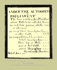
As illustrated to the right (click on it for a larger view), tolls in 1851 on one such area road were 6 pence for every vehicle "drawn by two horses or other cattle" plus or minus adjustments for mules, asses or whatever. One tollkeeper sometimes collected tolls by extending a half coconut(!) attached to a stick out to the travellers (especially when they were sitting way-y-y up on top of bales of hay).
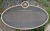
Davenport Road’s history can be traced back to the end of the Ice Ages, when the passageway was used as an ancient foot path by the
First Nations people seeking an overland route from Montreal to Niagara. It continued to be an important trail for French fur traders in the 1600's, and for the first European settlers who arrived in the area in the 1790's, and was slowly converted into

a built road during the 19th century. (
Click here for more about the history of Davenport Road.)
Major improvements to the road began in 1833, when the government of Upper Canada authorized the incorporation of companies to build, maintain and control specific sections of road. The winning bidder was responsible for improving the road and collecting tolls to recoup the investment. The companies built tollgates and
hired men to operate them. Between the Humber and Don Rivers, Davenport Road had five tollgates. Tollgate #3, which included a cottage to house the tollgate keeper and his family, and is the focus of this site, was at Davenport Road and Bathurst Street (then known as Cruikshank's Lane)..
Thus far, research has shown that Tollgate #3 was operating from at least 1850. The
Cottage has been dated at 1835 as it has construction features from the 1820s to 1840s. It re-used materials from other locations and may have been built elsewhere and moved to the site. An 1875 painting by Arthur Cox shows it on the east side of the road allowance. A later sketch by Marmaduke Matthews shows it moved to the west side, losing its front porch and rear addition in the process. By 1895 it had been relocated to a lot two blocks to the east to begin a second career as an ordinary residence. When that lot came under redevelopment, the building was threatened. The Community History Project (see "
About CHP”)

* and began raising funds to restore this historical treasure. Subsequently, the Toronto Transit Commission agreed to house the
cottage on its Wychwood Streetcar Barns Site, and in June 1996 CHP volunteers moved the
Cottage to that location.
With the
Cottage safely parked at the Wychwood Barns site, CHP continued to raise funds which were placed in the Tollkeeper’s Fund administered by
Heritage Toronto.. As of mid 2009, the COMMUNITY HISTORY PROJECT, now a charitable organization, issues receipts directly for donations.
After Toronto City Council gave permission for the
Cottage to be placed as close as possible to its original site, the
Cottage was moved to its current and permanent location in The Tollkeeper's Park (formerly Davenport Square Park) on the NW corner of Davenport Road and Bathurst Street.
Further information about
The Cottage is available
here. For an Opening Day (July 1, 2008) factual sketch,
click here.
___________________________________
*
rest cursor on above underlined text for more info.


 a built road during the 19th century. (Click here for more about the history of Davenport Road.)